Top Urban Hikes in San Francisco – Hike № 2 (9.1 miles / +/- 3.3 hours)
Photo by Kace Rodriguez on Unsplash
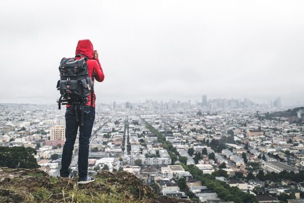
The best part about urban hiking in San Francisco is exploring so many interesting neighborhoods. Each is unique, offering its own share of surprises in terms of food, architecture, views, and an endless array of eclectic shops. One of my favorite long-distance urban hikes is to walk from McLaren Park, located at the city’s southern border, up to Crissy Field at the northern edge of the city. The estimated completion time for the hike, as noted above, is based on Google Maps information. However, your times may vary depending on your pace and whether you spend time exploring, snacking, dining, or taking a break at a local park.
Although this hike will take you through some commercial corridors where you can buy food or drinks, I still always recommend, at a minimum, packing 1) some water, 2) a snack or two, and 3) a jacket (light or heavy depending on the time of year). All are placed in a small backpack to be on the safe side. Also, please note the following comments and provisos:
- If you want to do some cardio work, choose the best time to exercise and hike while admiring the sights.
- If you want to explore the neighborhoods you’ll be visiting, choose a time that allows you to sightsee, window shop, and maybe stop and eat at least once.
- This is a suggested route. You can veer off the predetermined path to discover more varied and unique sights. You will probably use your mobile phone’s GPS to set your route.
- This route will take you through commercial corridors with great cafes and restaurants. You will decide whether to stop and enjoy some fine cuisine or soldier on.
- You can return the same way you came, catch public transit, or take a taxi to return home or to your starting point.
- If you have not noticed, San Francisco is a very hilly city. Therefore, on your hike, be aware that you will encounter challenging climbs.
McLaren Park to Crissy Field
- Head northwest out of the park on Excelsior Avenue and walk about 0.8 miles down to Mission Street, then make a right.
- You will then be on Mission Street for about 0.8 miles, allowing you to experience the atmosphere of the Excelsior and Outer Mission neighborhoods, including the shops, cafes, Latin-American restaurants, and grocery stores.
- After 0.8 miles, you can decide from the following options how you will continue your urban hike:
- Continue on Mission Street, which will take you through the heart of the Mission. There is a lot to see, with plenty of places to shop and enjoy some tasty Latin-American cuisine.
- Continue on Mission Street for another 0.7 miles, then turn left onto Valencia Street. Valencia is also part of the Mission, but it has a more hipster vibe and is a bit quieter than Mission Street.
- Continue on Mission Street for another 0.4 miles, then turn left onto Dolores Street. Dolores is a hilly street with great views in some locations. It will also take you past Dolores Park, a great place to take a break, have a picnic, or admire the views.
- Turn left onto Richland Street, which turns into Miguel Street, and then veer off onto Ladlley, which will take you to Castro Street at Billy Goat Hill. And, since you are right there, climb up Billy Goat Hill for the views. Mind you, this route requires a lot of climbing. Once you are on Castro Street, continue north through the Noe Valley neighborhood and then the Castro neighborhood. Noe Valley’s commercial corridor is on 24th Street, perpendicular to Castro Street, which I recommend checking out. Additionally, if you take this route, it will allow you to walk through the heart of the Castro district between 20th and 17th
- If you walk up Mission, Valencia, or Dolores Streets, continue until you reach Duboce Street. Then, make a right onto Duboce and walk several blocks until you reach Castro/Divisadero Street.
- Continue walking north on Divisadero Street for several miles until you reach Marina Boulevard. However, to detour quickly, turn left onto Beach Street, a couple of blocks before Marina Boulevard, and walk one long block to the. This landmark structure is an icon of San Francisco.
- Once you have walked around the Palace of Fine Arts, head north on Lyon Street and pass Marina Street/Boulevard to Crissy Field.
- Walk west on Crissy Field to the foot of the Golden Gate Bridge, which will be quite visible—the great walk along the shore at Crissy Field up to Fort Point National Historic Site. You have breathtaking views of the bridge right next to the Bay’s calm waters, and you are surrounded by nature in the middle of a densely populated city.
I hope you enjoy the hike. Let us know your thoughts and experiences by leaving a comment below.

Mike Doherty serves as Chief Experience Officer at Greening Projects, a nonprofit organization dedicated to transforming underutilized urban spaces into vibrant green areas
Trackbacks/Pingbacks